TMAP parameter group: Counts of birds washed ashore (BEAB). Data of the Beached-Birds-Survey The trilateral Monitoring and Assessment Program was established in 1994 and contains 28 chemical, biological, geological and common parameter. Analyses enable an assessment on the trilateral agreed ecological targets. Results are published as Quality status report regularly. Investigations are done with regard to the following issues of concern primarily (Kellermann, A. et al. 1994): - Effects of climate change on the morphology, - Effects of pollutant inputs (nutrients and contaminants) on processes, species and communities, - Effects of fisheries on species and communities, - Effects of recreational activities on species, - Effects of agricultural utilization on salt marsh communities.
TMAP parameter group: Water and air temperature, wind speed, ice coverage and NAO index (WEAC). Weather data measured by the DWD. The trilateral Monitoring and Assessment Program was established in 1994 and contains 28 chemical, biological, geological and common parameter. Analyses enable an assessment on the trilateral agreed ecological targets. Results are published as Quality status report regularly. Investigations are done with regard to the following issues of concern primarily (Kellermann, A. et al. 1994): - Effects of climate change on the morphology, - Effects of pollutant inputs (nutrients and contaminants) on processes, species and communities, - Effects of fisheries on species and communities, - Effects of recreational activities on species, - Effects of agricultural utilization on salt marsh communities.
TMAP parameter group: Counts of birds washed ashore (BEAB). Data of the Beached-Birds-Survey The trilateral Monitoring and Assessment Program was established in 1994 and contains 28 chemical, biological, geological and common parameter. Analyses enable an assessment on the trilateral agreed ecological targets. Results are published as Quality status report regularly. Investigations are done with regard to the following issues of concern primarily (Kellermann, A. et al. 1994): - Effects of climate change on the morphology, - Effects of pollutant inputs (nutrients and contaminants) on processes, species and communities, - Effects of fisheries on species and communities, - Effects of recreational activities on species, - Effects of agricultural utilization on salt marsh communities.
TMAP parameter group: Water and air temperature, wind speed, ice coverage and NAO index (WEAC). Weather data measured by the DWD. The trilateral Monitoring and Assessment Program was established in 1994 and contains 28 chemical, biological, geological and common parameter. Analyses enable an assessment on the trilateral agreed ecological targets. Results are published as Quality status report regularly. Investigations are done with regard to the following issues of concern primarily (Kellermann, A. et al. 1994): - Effects of climate change on the morphology, - Effects of pollutant inputs (nutrients and contaminants) on processes, species and communities, - Effects of fisheries on species and communities, - Effects of recreational activities on species, - Effects of agricultural utilization on salt marsh communities.
TMAP parameter group: Water and air temperature, wind speed, ice coverage and NAO index (WEAC). Weather data measured by the DWD. The trilateral Monitoring and Assessment Program was established in 1994 and contains 28 chemical, biological, geological and common parameter. Analyses enable an assessment on the trilateral agreed ecological targets. Results are published as Quality status report regularly. Investigations are done with regard to the following issues of concern primarily (Kellermann, A. et al. 1994): - Effects of climate change on the morphology, - Effects of pollutant inputs (nutrients and contaminants) on processes, species and communities, - Effects of fisheries on species and communities, - Effects of recreational activities on species, - Effects of agricultural utilization on salt marsh communities.
TMAP parameter group: Water and air temperature, wind speed, ice coverage and NAO index (WEAC). Weather data measured by the DWD. The trilateral Monitoring and Assessment Program was established in 1994 and contains 28 chemical, biological, geological and common parameter. Analyses enable an assessment on the trilateral agreed ecological targets. Results are published as Quality status report regularly. Investigations are done with regard to the following issues of concern primarily (Kellermann, A. et al. 1994): - Effects of climate change on the morphology, - Effects of pollutant inputs (nutrients and contaminants) on processes, species and communities, - Effects of fisheries on species and communities, - Effects of recreational activities on species, - Effects of agricultural utilization on salt marsh communities.
TMAP parameter group: Water and air temperature, wind speed, ice coverage and NAO index (WEAC). Weather data measured by the DWD. The trilateral Monitoring and Assessment Program was established in 1994 and contains 28 chemical, biological, geological and common parameter. Analyses enable an assessment on the trilateral agreed ecological targets. Results are published as Quality status report regularly. Investigations are done with regard to the following issues of concern primarily (Kellermann, A. et al. 1994): - Effects of climate change on the morphology, - Effects of pollutant inputs (nutrients and contaminants) on processes, species and communities, - Effects of fisheries on species and communities, - Effects of recreational activities on species, - Effects of agricultural utilization on salt marsh communities.
Die Daten werden hier zentral angeboten und sind über den Themenbaum im und über passende Filterformulare direkt von aus dem Data Warehouse des Landes SH in harmonisierter und aggregierter Form abrufbar. Für den Nutzer sind bereits vorgefertigte Auswertungen unter "Ansichten" verfügbar.
Das Angebot zum Thema Makrozoobenthos umfasst derzeit die folgenden Zusammenstellungen:
MZB: ein Jahr: Abundanz und Biomasse (Jahresmittel) MZB: Zeitreihe Abundanz und Biomasse (Jahresmittel) MZB: eine Messstelle: Abundanz und Biomasse (Jahresmittel) MZB: Küstenmessstellen
Diese ungefilterte aber geprüfte Datentabellle stellt alle ab 1989 verfügbaren Seehund und Kegelrobben-Daten aus Zählflügen im Bereich des Nationalparks Schleswig-Holsteinischen Wattenmeer zur Verfügung. Es handelt sich bei den Daten einerseits um Erfassungen die während der Seehund-Flüge in den Monaten Mai - Juli (Wurfzeit) und August - September (Haarwechselzeit) durchgeführt werden, andererseits aber auch um Daten, die während der Kegelrobben-Flüge in den Monaten November - April erfasst wurden. Da es sich um eine UIG entsprechende vollständige Weitergabe der aufbereiteten Rohdaten handelt, wurde keine methodische oder biologische Filterung der Daten vorgenommen. Daher sind die Daten für eine Bestandsberechnung nur nach ansprechender Filterung möglich.
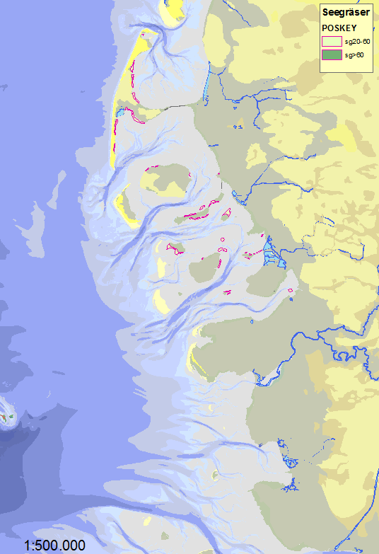
Flugzeugkartierungen von Seegraswiesen seit 1991 im Rahmen des trilateralen Monitoring-Programmes (TMAP).Polygon- und Liniencover. 2 Dichteklassen der geschlossnenen Bestände werden erfasst. Die Identifizierung der Flächen vom Sportflugzeug aus ist erst ab ca. 25% Deckung möglich, Zostera nana und Z. marina werden nicht unterschieden. Die Ergebnisse werden entsprechend den Beobachtungen in Karten eingetragen, bei landfernen Beständen sind die Lageungenauigkeiten größer. Aus den Jahren 1989 und 1990 liegen ähnliche, aber in der Klassifikation abweichende, Kartierungen im Rahmen der Ökosystemforschung Schleswig-Holsteinsches Wattenmeer vor.