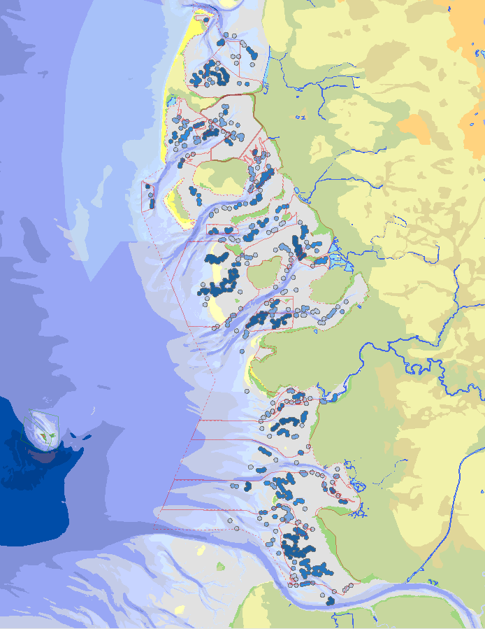
Dienstbezogener Datenbestand zu den Ruheplätzen von Seehunden. Ein Ruheplatz ist eine berechnete Fläche, die auf Basis einzelner Liegeplätze von Seehunden bzw. Kegelrobben generiert wird. Dazu werden die Liegeplätze pro Jahr räumlich zusammengefasst. Ein Ruheplatz wird als Kreis mit einem Radius von 500m um einen Liegeplatz (mit mind. 2 Seehunden) herum definiert, wobei mehrere Liegeplätze so zu einer größeren Fläche aggregiert werden können. Der Abstand von 500m wurde gewählt, da Störungen, die mehr als 500m entfernt sind, keine oder kaum Auswirkungen auf ruhende Robben haben. Diese Flächen werden für Eingriffsplanungen benötigt, um die mit dem Eingriff verbundenen Störungen der Robben auf ein Mindestmaß zu reduzieren. Für Seehunde werden zur Berechnung der Ruheplätze pro Jahr Flüge vom 1.03-30.09 berücksichtigt. Der Dienst beinhaltet folgende Informationen: die Lage und Größe des Ruheplatzes und den Zeitraum der Erfassungen, die in die Berechnung eingeflossen sind.
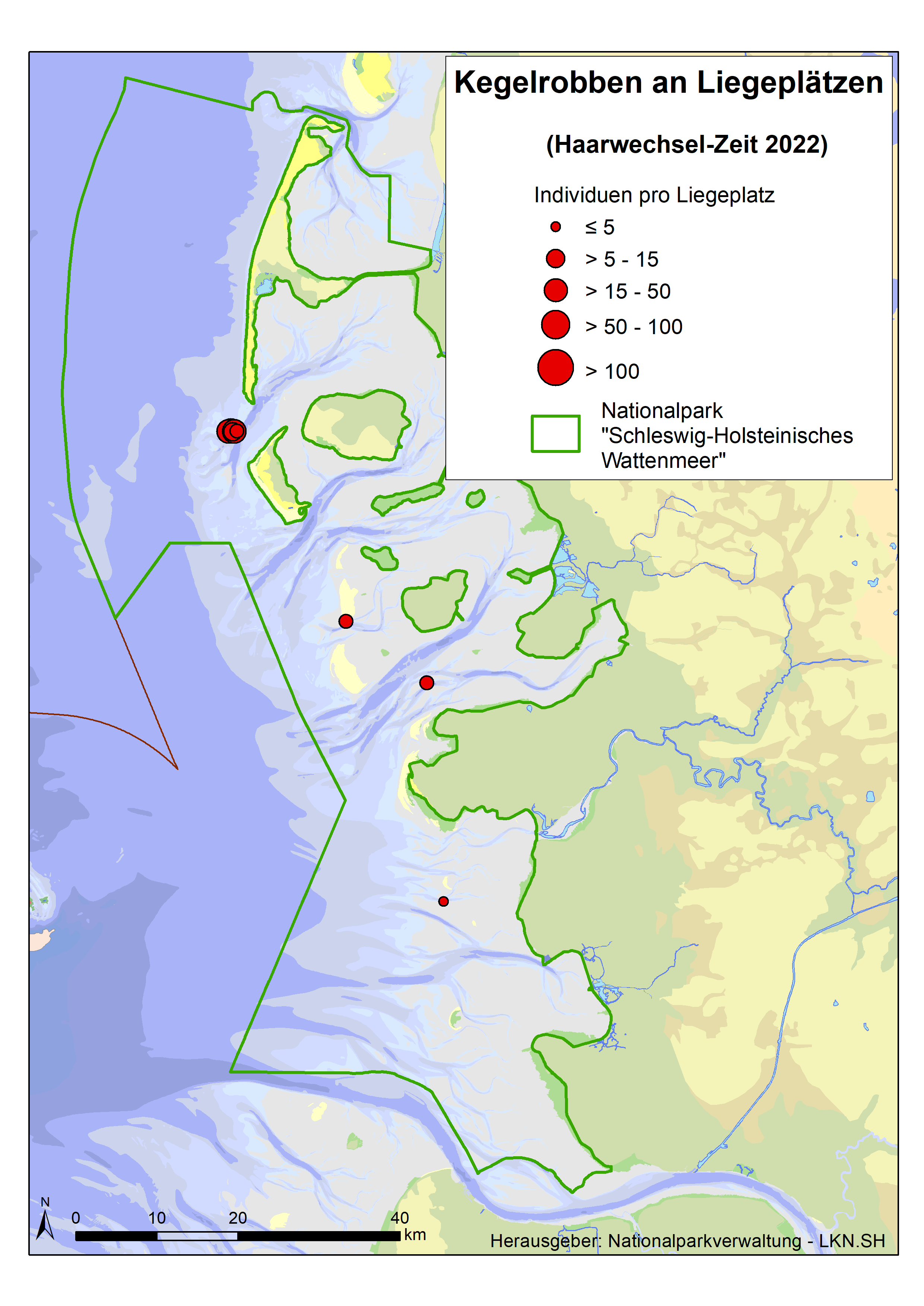
Dieser diesntbezogene Datenbestand stellt ab 2005 Daten des Kegelrobben-Monitorings im Bereich des Nationalparks Schleswig-Holsteinischen Wattenmeer zur Verfügung. Es handelt sich bei den Daten um flächendeckende Flugzeuggestützte Erfassungen ab 2005 in den für Kegelrobben relevanten Jahreszeiten: In der Regel werden pro Jahr zur Wurfzeit (November - Januar) drei Erfassungen und zur Haarwechselzeit (März – April) zwei Erfassungen durchgeführt. Sichtungen außerhalb dieses Zeitraumes werden in diesem Datensatz nicht zur Verfügung gestellt (siehe dazu Robben: Robben: Monitoring der Bestände von Seehunden und Kegelrobben im Schleswig-Holsteinischen Wattenmeer ab 1989, Objekt-ID:c9821815-de30-4559-8250-8046bfe5fc22). Während des Kegelrobben-Monitorings wird allen gezählten Einzeltieren bzw. Gruppen eine punktgenaue Koordinate zugewiesen, die als Liegeplatz definiert ist. Wenn möglich wird bei der Zählung nach adulten und juvenilen Tieren unterschieden. Für Bestandsberechnungen können die Daten nach einzelnen Erfassungsflügen gefiltert werden. Spalte „Robbenjahr“: Die Wurfzeit der Kegelrobben findet über den Jahreswechsel zwischen November und Januar des folgenden Jahres statt. Um eine Bearbeitung und Filterung der Daten zur vereinfachen wurde die Spalte "Robbenjahr" eingefügt, die für Kegelrobben die Monate November und Dezember dem Folgejahr zuordnet, damit die Wurfzeit nicht bei einer Selektion des Erfassungsjahres gesplittet wird.
Die hier beschriebenen Daten können über den zugehörigen Dienst "(WFS) Kegelrobben - Liegeplätze" (Objekt-ID:a11b2dcc-5d21-4c70-bb6b-3556db2cfc2b) abgerufen werden. Zudem werden die einzelnen Jahres-Layer mit allen Flügen pro Jahr als WMS-Darstellungsdienst angeboten (Objekt-ID: ####).
Die folgende Basis-Tabelle enthält alle Kegelrobben-Sichtungen, die zusätzlich außerhalb des spezifischen Monitoringzeitraums getätigt wurden: Robben: Robben: Monitoring der Bestände von Seehunden und Kegelrobben im Schleswig-Holsteinischen Wattenmeer ab 1989, Objekt-ID:c9821815-de30-4559-8250-8046bfe5fc22).
Auf Grundlage der Liegeplatz-Daten wurden zur Bewertung von Eingriffen auch die Ruheplätze der Kegelrobben berechnet und als Dienst bereitgestellt: (WFS) - Kegelrobben: Ruheplätze, Objekt-ID:b68ffc9f-c7fe-409e-9c5f-df17230bb387
TMAP parameter group: Counts of migratory birds (MIGB). Counts of Migratory Birds in the Wadden Sea The trilateral Monitoring and Assessment Program was established in 1994 and contains 28 chemical, biological, geological and common parameter. Analyses enable an assessment on the trilateral agreed ecological targets. Results are published as Quality status report regularly. Investigations are done with regard to the following issues of concern primarily (Kellermann, A. et al. 1994): - Effects of climate change on the morphology, - Effects of pollutant inputs (nutrients and contaminants) on processes, species and communities, - Effects of fisheries on species and communities, - Effects of recreational activities on species, - Effects of agricultural utilization on salt marsh communities.
TMAP parameter group: Measurement of inorganic nutrients in water (in CD). Nutrients in water The trilateral Monitoring and Assessment Program was established in 1994 and contains 28 chemical, biological, geological and common parameter. Analyses enable an assessment on the trilateral agreed ecological targets. Results are published as Quality status report regularly. Investigations are done with regard to the following issues of concern primarily (Kellermann, A. et al. 1994): - Effects of climate change on the morphology, - Effects of pollutant inputs (nutrients and contaminants) on processes, species and communities, - Effects of fisheries on species and communities, - Effects of recreational activities on species, - Effects of agricultural utilization on salt marsh communities.
TMAP parameter group: Species, cell numbers and biomass of phytoplankton (BICO). Information about Phytoplankton: cell number, biomass and Chl-A content The trilateral Monitoring and Assessment Program was established in 1994 and contains 28 chemical, biological, geological and common parameter. Analyses enable an assessment on the trilateral agreed ecological targets. Results are published as Quality status report regularly. Investigations are done with regard to the following issues of concern primarily (Kellermann, A. et al. 1994): - Effects of climate change on the morphology, - Effects of pollutant inputs (nutrients and contaminants) on processes, species and communities, - Effects of fisheries on species and communities, - Effects of recreational activities on species, - Effects of agricultural utilization on salt marsh communities.
TMAP parameter group: Area and location, zones, drainage and agricultural utilization of salt marshes (in GD). Salt marshes The trilateral Monitoring and Assessment Program was established in 1994 and contains 28 chemical, biological, geological and common parameter. Analyses enable an assessment on the trilateral agreed ecological targets. Results are published as Quality status report regularly. Investigations are done with regard to the following issues of concern primarily (Kellermann, A. et al. 1994): - Effects of climate change on the morphology, - Effects of pollutant inputs (nutrients and contaminants) on processes, species and communities, - Effects of fisheries on species and communities, - Effects of recreational activities on species, - Effects of agricultural utilization on salt marsh communities.
TMAP parameter group: TBT in sediment (in CD). TBT contamination in sediment The trilateral Monitoring and Assessment Program was established in 1994 and contains 28 chemical, biological, geological and common parameter. Analyses enable an assessment on the trilateral agreed ecological targets. Results are published as Quality status report regularly. Investigations are done with regard to the following issues of concern primarily (Kellermann, A. et al. 1994): - Effects of climate change on the morphology, - Effects of pollutant inputs (nutrients and contaminants) on processes, species and communities, - Effects of fisheries on species and communities, - Effects of recreational activities on species, - Effects of agricultural utilization on salt marsh communities.
TMAP parameter group: Take offs and landings in the Wadden Sea Area (AIRT). Take offs and landings in the Wadden Sea Area The trilateral Monitoring and Assessment Program was established in 1994 and contains 28 chemical, biological, geological and common parameter. Analyses enable an assessment on the trilateral agreed ecological targets. Results are published as Quality status report regularly. Investigations are done with regard to the following issues of concern primarily (Kellermann, A. et al. 1994): - Effects of climate change on the morphology, - Effects of pollutant inputs (nutrients and contaminants) on processes, species and communities, - Effects of fisheries on species and communities, - Effects of recreational activities on species, - Effects of agricultural utilization on salt marsh communities.
TMAP parameter group: Number of boats at sea (BTAS). Statistics about boats at sea The trilateral Monitoring and Assessment Program was established in 1994 and contains 28 chemical, biological, geological and common parameter. Analyses enable an assessment on the trilateral agreed ecological targets. Results are published as Quality status report regularly. Investigations are done with regard to the following issues of concern primarily (Kellermann, A. et al. 1994): - Effects of climate change on the morphology, - Effects of pollutant inputs (nutrients and contaminants) on processes, species and communities, - Effects of fisheries on species and communities, - Effects of recreational activities on species, - Effects of agricultural utilization on salt marsh communities.
TMAP parameter group: Number of boats at sea (BTAS). Statistics about boats at sea The trilateral Monitoring and Assessment Program was established in 1994 and contains 28 chemical, biological, geological and common parameter. Analyses enable an assessment on the trilateral agreed ecological targets. Results are published as Quality status report regularly. Investigations are done with regard to the following issues of concern primarily (Kellermann, A. et al. 1994): - Effects of climate change on the morphology, - Effects of pollutant inputs (nutrients and contaminants) on processes, species and communities, - Effects of fisheries on species and communities, - Effects of recreational activities on species, - Effects of agricultural utilization on salt marsh communities.