TMAP parameter group: Contaminants in flounder (in CD). Gemeinsames Bund/Länder-Messprogramm für die Nordsee The trilateral Monitoring and Assessment Program was established in 1994 and contains 28 chemical, biological, geological and common parameter. Analyses enable an assessment on the trilateral agreed ecological targets. Results are published as Quality status report regularly. Investigations are done with regard to the following issues of concern primarily (Kellermann, A. et al. 1994): - Effects of climate change on the morphology, - Effects of pollutant inputs (nutrients and contaminants) on processes, species and communities, - Effects of fisheries on species and communities, - Effects of recreational activities on species, - Effects of agricultural utilization on salt marsh communities.
TMAP parameter group: Contaminants in flounder (in CD). Gemeinsames Bund/Länder-Messprogramm für die Nordsee The trilateral Monitoring and Assessment Program was established in 1994 and contains 28 chemical, biological, geological and common parameter. Analyses enable an assessment on the trilateral agreed ecological targets. Results are published as Quality status report regularly. Investigations are done with regard to the following issues of concern primarily (Kellermann, A. et al. 1994): - Effects of climate change on the morphology, - Effects of pollutant inputs (nutrients and contaminants) on processes, species and communities, - Effects of fisheries on species and communities, - Effects of recreational activities on species, - Effects of agricultural utilization on salt marsh communities.
TMAP parameter group: Contaminants in blue mussel (in CD). Gemeinsames Bund/Länder-Messprogramm für die Nordsee The trilateral Monitoring and Assessment Program was established in 1994 and contains 28 chemical, biological, geological and common parameter. Analyses enable an assessment on the trilateral agreed ecological targets. Results are published as Quality status report regularly. Investigations are done with regard to the following issues of concern primarily (Kellermann, A. et al. 1994): - Effects of climate change on the morphology, - Effects of pollutant inputs (nutrients and contaminants) on processes, species and communities, - Effects of fisheries on species and communities, - Effects of recreational activities on species, - Effects of agricultural utilization on salt marsh communities.
TMAP parameter group: Contaminants in blue mussel (in CD). Gemeinsames Bund/Länder-Messprogramm für die Nordsee The trilateral Monitoring and Assessment Program was established in 1994 and contains 28 chemical, biological, geological and common parameter. Analyses enable an assessment on the trilateral agreed ecological targets. Results are published as Quality status report regularly. Investigations are done with regard to the following issues of concern primarily (Kellermann, A. et al. 1994): - Effects of climate change on the morphology, - Effects of pollutant inputs (nutrients and contaminants) on processes, species and communities, - Effects of fisheries on species and communities, - Effects of recreational activities on species, - Effects of agricultural utilization on salt marsh communities.
TMAP parameter group: Contaminants in blue mussel (in CD). Gemeinsames Bund/Länder-Messprogramm für die Nordsee The trilateral Monitoring and Assessment Program was established in 1994 and contains 28 chemical, biological, geological and common parameter. Analyses enable an assessment on the trilateral agreed ecological targets. Results are published as Quality status report regularly. Investigations are done with regard to the following issues of concern primarily (Kellermann, A. et al. 1994): - Effects of climate change on the morphology, - Effects of pollutant inputs (nutrients and contaminants) on processes, species and communities, - Effects of fisheries on species and communities, - Effects of recreational activities on species, - Effects of agricultural utilization on salt marsh communities.
TMAP parameter group: Contaminants in blue mussel (in CD). Gemeinsames Bund/Länder-Messprogramm für die Nordsee The trilateral Monitoring and Assessment Program was established in 1994 and contains 28 chemical, biological, geological and common parameter. Analyses enable an assessment on the trilateral agreed ecological targets. Results are published as Quality status report regularly. Investigations are done with regard to the following issues of concern primarily (Kellermann, A. et al. 1994): - Effects of climate change on the morphology, - Effects of pollutant inputs (nutrients and contaminants) on processes, species and communities, - Effects of fisheries on species and communities, - Effects of recreational activities on species, - Effects of agricultural utilization on salt marsh communities.
Mittelwert von Cadmium im Sediment in der Korngrößenfraktion < 20 µm von 2005 bis 2010 vom Landesamt für Landwirtschaft, Umwelt und ländliche Räume Schleswig-Holstein. Stand der Datenbank vom 30.03.2012.
Mittelwert von Cadmium in 1m Wassertiefe von 2005 bis 2010 vom Landesamt für Landwirtschaft, Umwelt und ländliche Räume Schleswig-Holstein. Stand der Datenbank vom 30.03.2012.
Mittelwert von Cadmium im Sediment in der Korngrößenfraktion <2000µm von 2005 bis 2010 vom Landesamt für Landwirtschaft, Umwelt und ländliche Räume Schleswig-Holstein. Stand der Datenbank vom 30.03.2012.
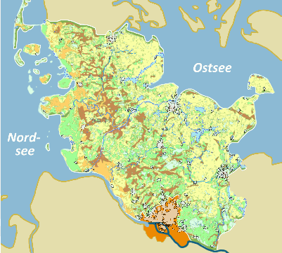
Der Datensatz "Cadmium - Hintergrundwerte stofflich gering beeinflusster Böden Schleswig-Holsteins" enthält für Cadmium die 90er-Perzentilwerte von 13 Auswerteklassen als landesweite Kartendarstellung. Die Auswerteklassen werden aus Informationen zu den Nutzungen Acker, Grünland und Wald sowie zum Boden (Bodenart/Torfe, Bodentypen) gebildet. In der Karte werden regional noch als typisch einzuschätzende Arsengehalte als Hintergrundwerte dargestellt. Als Klassengrenzen für die farbliche Abstufung werden die 50er-, 75er-, 90er- und 95-Perzentilwerte des Gesamtdatenbestandes ohne Waldauflagen verwendet. So lassen sich gegenüber einer für ganz Schleswig-Holstein über alle Nutzungen gültigen Verteilung gebietsbezogene Einheiten in ihrer Tendenz gut darstellen.